Chapter 5
Traffic and alerts
The point of the app is to tell you, early and out loud, about traffic that matters to your flight, and stay quiet about traffic that doesn't. You decide what matters with rules. This chapter covers reading traffic on the map, the rules for aircraft and drones, and the controls that hide, mute or adjust traffic.
5.1Aircraft on the map
Each aircraft is drawn pointing the way it's flying, with its altitude beside it. The altitude is relative to you (or your point of interest), so 500ft means 500 feet above you, and a minus sign means below. Its color comes from the first alert rule it matches (Alert rules for aircraft).
Long-press an aircraft for its menu:
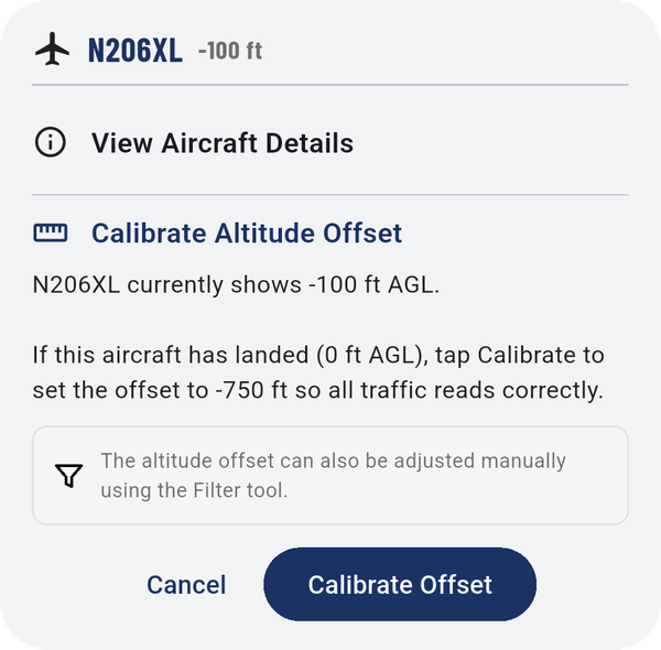
- View Aircraft Details: tail number, model and speed, plus switches to show its N-number and its recent trail on the map.
- Calibrate Altitude Offset: if you can see the aircraft is on the ground but the app shows it above or below you, tap Calibrate Offset. The app sets the offset so this aircraft reads 0 ft, and all other traffic reads correctly too. You can also set the offset by hand in Altitude settings.
5.2Alert rules for aircraft
A rule says: traffic within this distance and this altitude gets this color, this sound, and repeats this often. The app checks the rules from the top down; the first one an aircraft matches decides how it's shown and spoken.
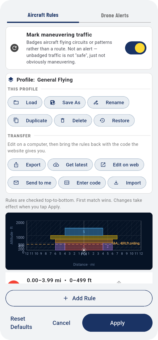
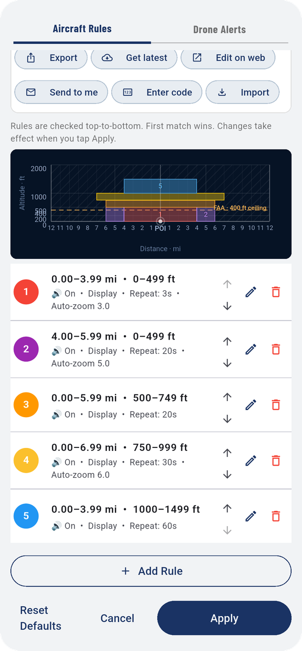
The chart shows your rules as colored boxes: distance across, altitude up, with the FAA's 400 ft ceiling as a dashed line. It's the quickest way to see gaps or overlaps.
Each rule in the list shows its number and color, its distance and altitude range, and whether it speaks (🔊 On), shows on the map (Display), how often it repeats, and whether it zooms the map in.
- Move up / Move down arrows change the order. Order matters: first match wins.
- The pencil edits a rule (Edit a rule); the trash can deletes it.
- Add Rule adds a new one.
- Reset Defaults brings back the factory rules.
- Apply saves your changes. Nothing changes until you tap it.
Mark maneuvering traffic, at the top, puts a small badge on aircraft flying circuits or patterns rather than a route. It isn't an alert: an unbadged aircraft isn't "safe", just not obviously maneuvering.
5.3Edit a rule
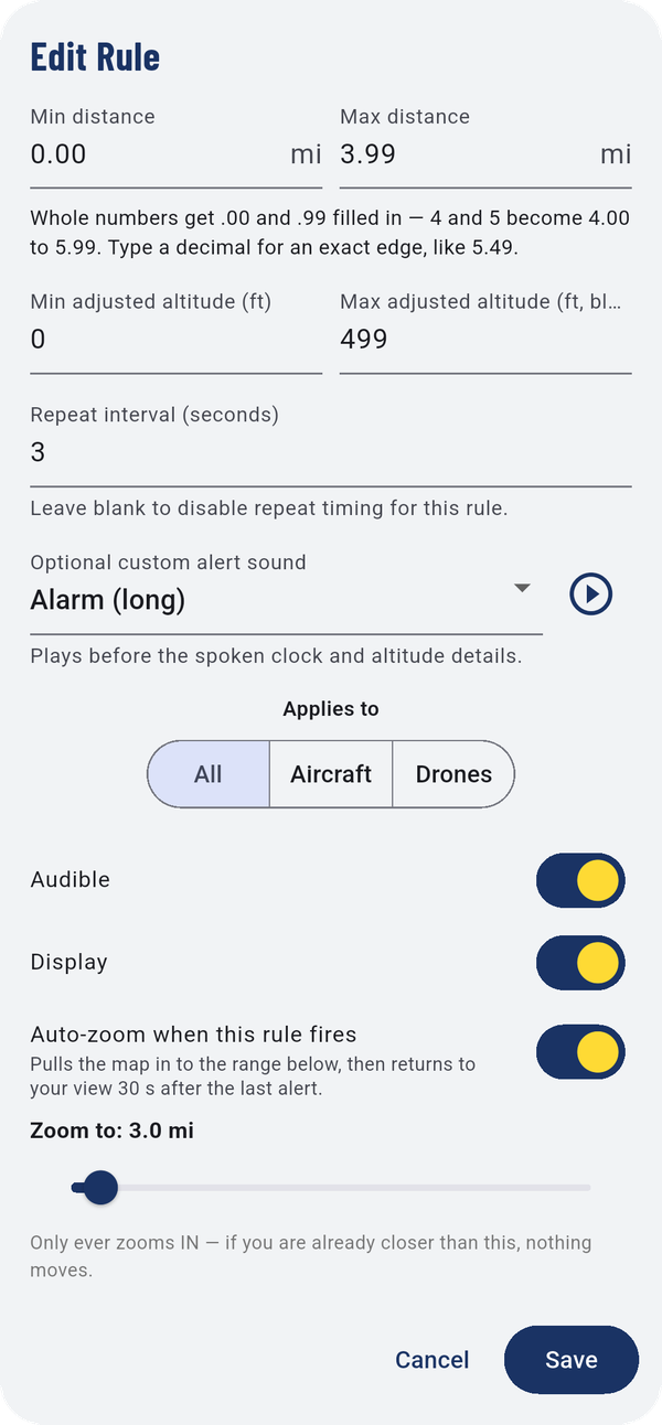
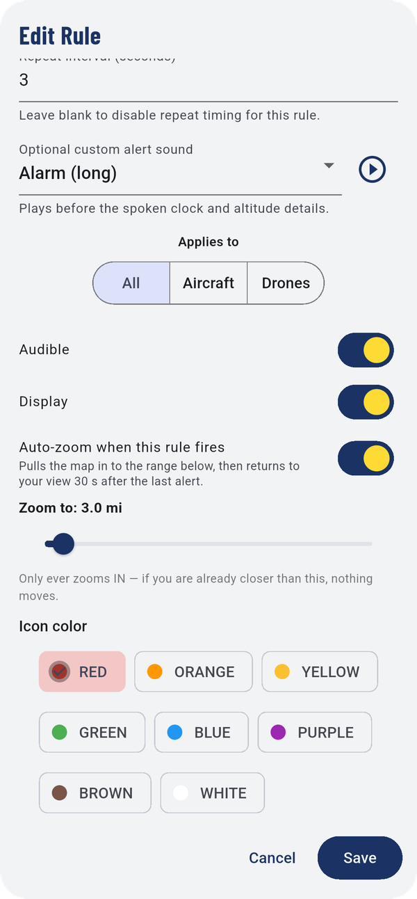
| Field | What it does |
|---|---|
| Min distance / Max distance | How far away, in miles. Whole numbers get .00 and .99 filled in, so rules of 0–3 and 4–5 meet without a gap. Type a decimal, like 5.49, for an exact edge. |
| Min adjusted altitude / Max adjusted altitude | Height above or below you, in feet. Leave the maximum blank for no limit. |
| Repeat interval (seconds) | How often to speak again while the aircraft stays in this rule. Blank means once. |
| Optional custom alert sound | A sound played before the spoken clock position and altitude. ▶ plays it. |
| Applies to | All, Aircraft or Drones. |
| Audible | Speak this rule. |
| Display | Show matching traffic on the map. |
| Auto-zoom when this rule fires | Zooms the map in to Zoom to, then returns to your view 30 seconds after the last alert. It only ever zooms in. |
| Icon color | The color for matching traffic. |
Tap Save, then Apply in the Rules window.
5.4Rule profiles
A profile is a complete set of rules under a name, so you can switch between, say, General Flying and crop-dusting work in a couple of taps.
- THIS PROFILE: Load, Save As, Rename, Duplicate, Delete, and Restore (put a built-in profile back the way it shipped).
- TRANSFER: edit your rules on a computer, then bring them back with the code the website gives you. Edit on web opens the rule editor and Enter code brings the result back. Export and Import move a rules file between devices. Send to me and Get latest are here too.
Your drone alert settings travel with the rules file.
5.5Drone alerts
Needs a Remote ID receiver
With a Remote ID receiver, Rules has a second tab, Drone Alerts. Distances are measured from the receiver. An alert speaks once per approach, after two reports agree.
Delivery drones
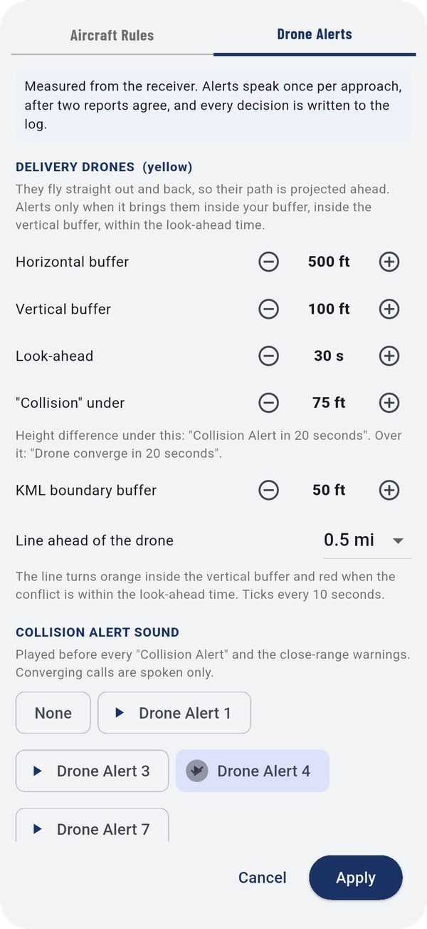
Delivery drones fly straight out and back, so the app projects their path ahead and warns you only when that path will bring one inside your buffer:
- Horizontal buffer and Vertical buffer: how close counts as a conflict.
- Look-ahead: how far ahead in time to check.
- "Collision" under: below this height difference you hear "Collision Alert in 20 seconds"; above it, "Drone converge in 20 seconds".
- KML boundary buffer: extra margin around a reference area you loaded.
- Line ahead of the drone: the length of the line drawn ahead of a delivery drone. It turns orange inside the vertical buffer and red when the conflict is within the look-ahead time, with a tick every 10 seconds.
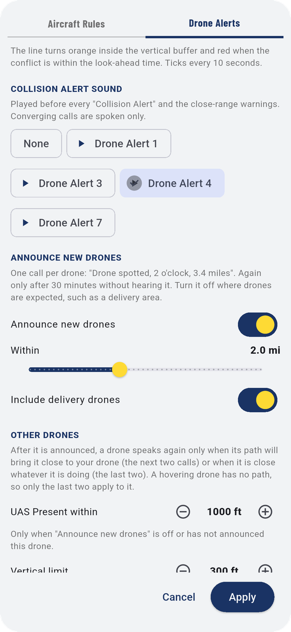
COLLISION ALERT SOUND is the sound played before every "Collision Alert" and close-range warning. Tap a sound to hear it.
Announce new drones
With Announce new drones on, the app makes one call per drone when it first appears, like "Drone spotted, 2 o'clock, 3.4 miles", and again only after 30 minutes without hearing it. Within sets how far out to announce. Turn it off where drones are expected, such as near a delivery area.
Other drones
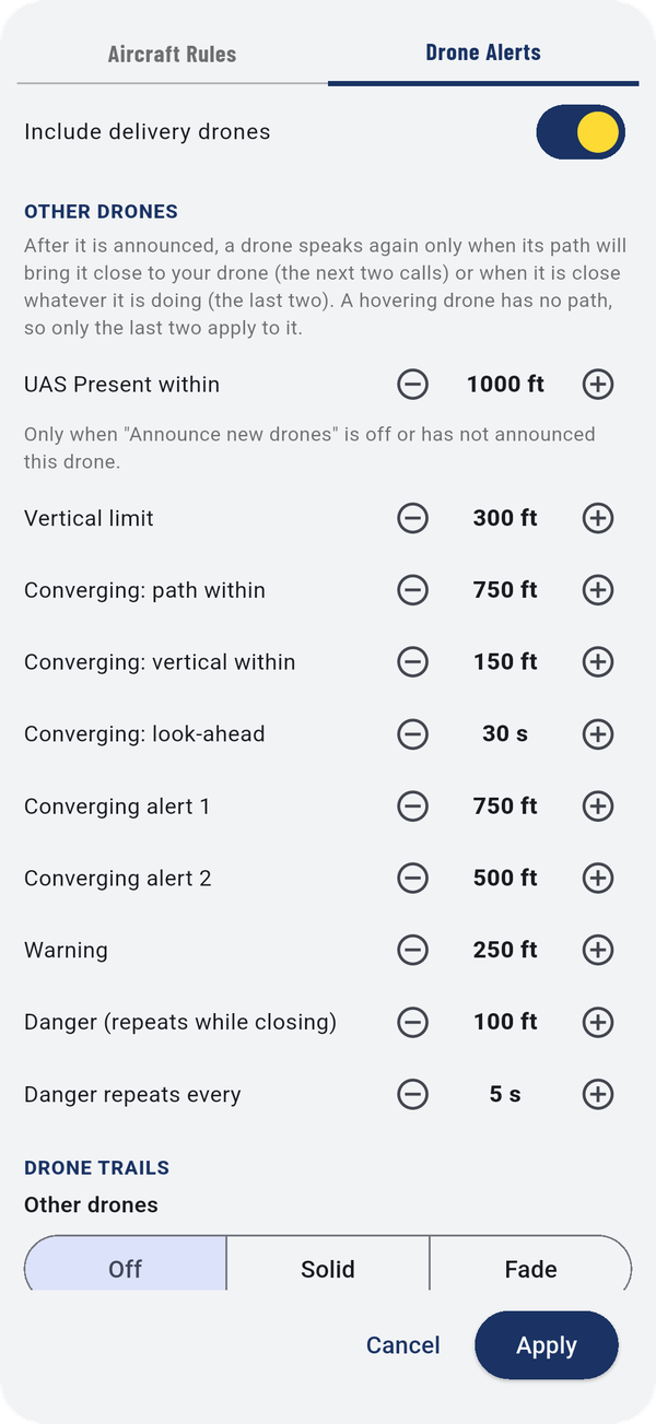
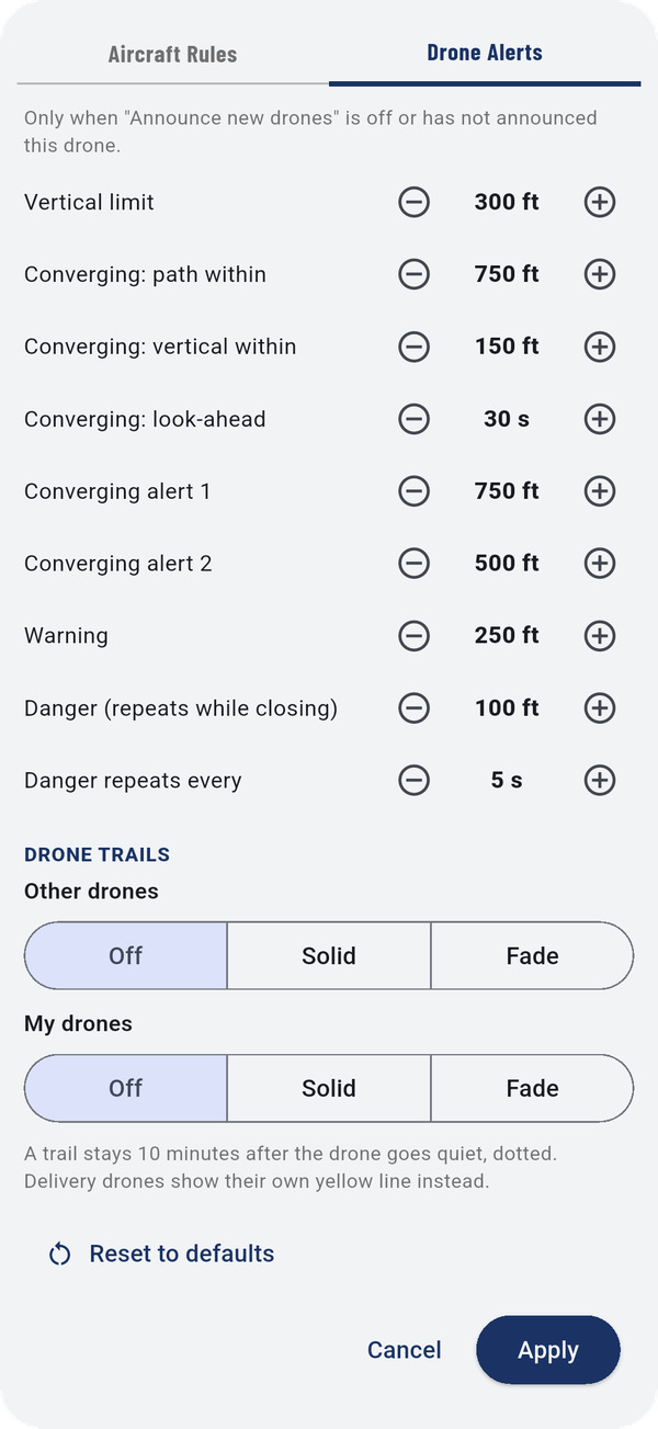
After a drone is announced, it speaks again only when its path will bring it close to your drone, or when it's close whatever it's doing. A hovering drone has no path, so only the last two apply to it.
- UAS Present within, Vertical limit.
- Converging: path within, vertical within and look-ahead.
- Converging alert 1 and 2, Warning, and Danger (repeats while closing), each a distance. Danger repeats every sets the repeat.
Drone trails
Separately for Other drones and My drones: Off, Solid, or Fade. A trail stays 10 minutes after a drone goes quiet, dotted. Delivery drones show their own yellow line instead.
Every number has − and + buttons. Reset to defaults puts them all back. Tap Apply to save.
5.6Alert volume
Alert volume sets the minimum loudness of spoken alerts, from 50% to 100%. The app restores it every time it starts, so alerts are never lost to a phone that was left turned down.
5.7Hide traffic you don't need
Visibility Settings hides traffic above an altitude, below an altitude, or beyond a distance. Leave a field blank to show everything.
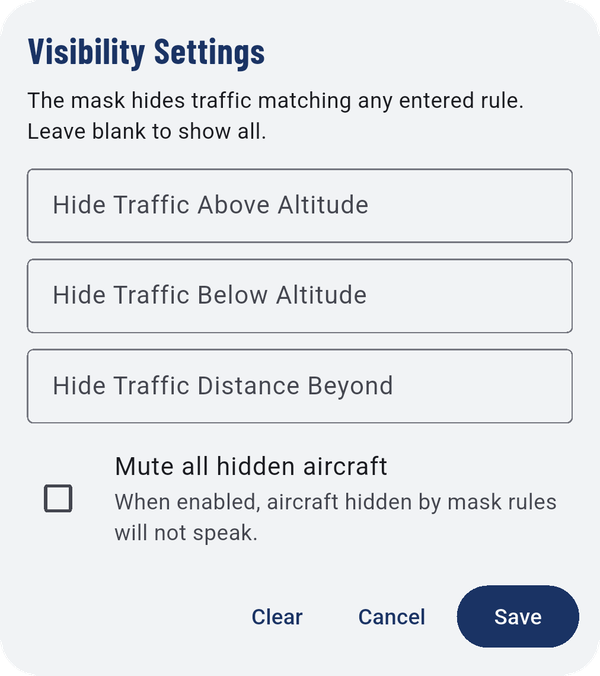
Mute all hidden aircraft also stops hidden traffic from speaking. The app asks you to confirm before turning this on, because a muted aircraft can't warn you.
While a filter is on, Filter turns gold, so you always see that something is hidden. Clear removes the filter.
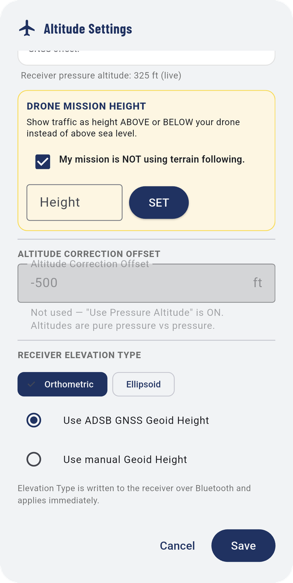
5.8Altitude settings
These settings decide how traffic altitudes are worked out relative to you. What you see depends on your receiver.
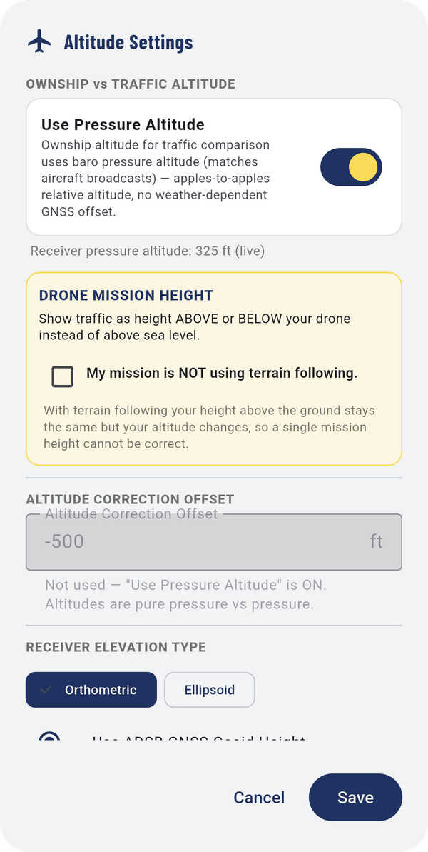
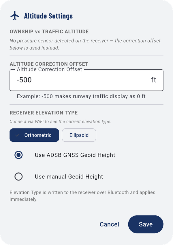
- Use Pressure Altitude: receivers with a pressure sensor compare traffic against your own pressure altitude, which is the most accurate method. The live reading is shown underneath.
- ALTITUDE CORRECTION OFFSET: without a pressure sensor, the app applies this offset instead. For example, -500 makes traffic on the runway display as 0 ft. The quickest way to set it is Aircraft on the map → Calibrate Altitude Offset.
- RECEIVER ELEVATION TYPE: Orthometric or Ellipsoid, and whether to use the receiver's measured geoid height or one you enter.
5.9Drone mission height
Needs a receiver
With pressure altitude on, DRONE MISSION HEIGHT lets you tell the app how high your drone is flying, so plane heights are spoken relative to your drone rather than to you on the ground.
- Tick My mission is NOT using terrain following.
- Enter the Height (ft AGL) and tap SET.
CLEAR turns it off.
5.10Silence all traffic
Silence ALL traffic stops every traffic callout for 1, 2, 3, 5 or 10 minutes.
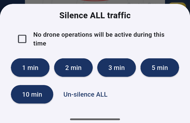
You must tick No drone operations will be active during this time first. It's there because silencing traffic while you're flying removes your warnings. Un-silence ALL turns the voice back on at any time.